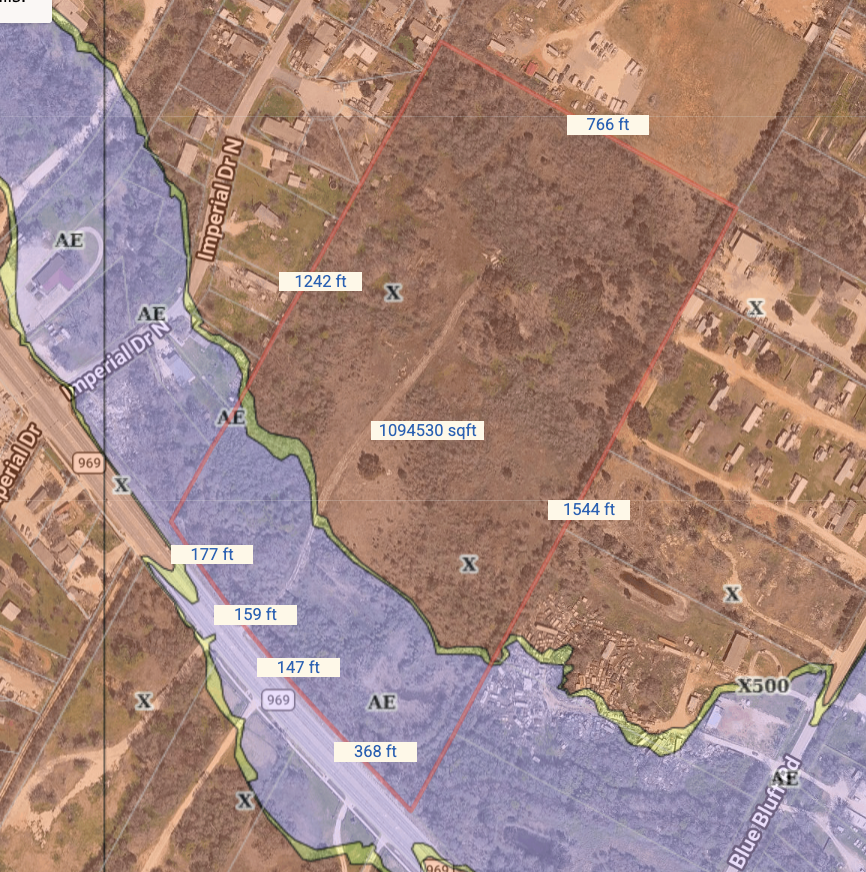
modernist exterior shot archsynth prompt use uploaded site boundary image as base layer important use the uploaded aerial screenshot as the base image and preserve the existing red property boundary exactly as shown build the conceptual site plan directly within the outlined parcel the rendering should look like a professional industrial developer s feasibility study and marketing package project overview create a high altitude aerial conceptual master plan for a modern industrial distribution center on the property shown in the uploaded image the uploaded screenshot contains the actual site boundaries outlined in red maintain those boundaries and use the surrounding roads neighboring properties and site context shown in the image site characteristics total site area approximately 25 acres frontage along highway 969 existing property boundary shown in red existing aerial imagery should remain visible beneath the proposed development site currently appears largely undeveloped development constraints assume a maximum 60 impervious cover across the entire site the layout should demonstrate a realistic development scenario that complies with this impervious cover limitation while maximizing industrial utility and value allocate land for building footprint truck courts trailer storage employee parking drive aisles detention facilities landscaping buffers stormwater infrastructure internal circulation building program design a modern class a regional distribution facility of approximately 350 000 400 000 sf include cross dock warehouse 36 40 foot clear height 80 120 dock doors 4 6 drive in ramps large truck courts dedicated truck circulation loop trailer storage area security controlled access corporate office entrance facing highway 969 employee and visitor parking site planning goals maximize industrial development potential while remaining believable from an engineering and land planning perspective the project should resemble facilities developed by amazon fedex ups walmart distribution dhl prologis duke realty trammell crow hillwood floodplain open space strategy utilize lower intensity areas of the site for regional detention ponds bioswales landscaping decorative water features truck staging open space buffers the site should clearly demonstrate compliance with the 60 impervious cover limitation while maintaining a highly efficient industrial layout camera position render from a high aerial perspective approximately 1 000 1 500 feet above the site requirements entire property visible entire building visible parking visible truck courts visible highway frontage visible surrounding neighborhood visible building footprint easily understood rendering style ultra realistic institutional quality development rendering the final image should look like an industrial development feasibility study a broker marketing package a conceptual land plan prepared for investors a presentation to a logistics user evaluating the site key visual message the image should immediately communicate this 25 acre tract along highway 969 can support a major 350 000 400 000 sf regional logistics facility while remaining within a 60 impervious cover limit and maintaining high operational efficiency label key features clearly label distribution facility truck courts trailer storage employee parking security gatehouse highway 969 frontage detention pond landscape buffer property boundary approximate building square footage approximate impervious cover percentage desired outcome produce a visually compelling aerial development concept that would help a landowner broker developer investor or industrial user understand the highest and best use potential of the site the finished rendering should feel realistic buildable and financially attractive architecture