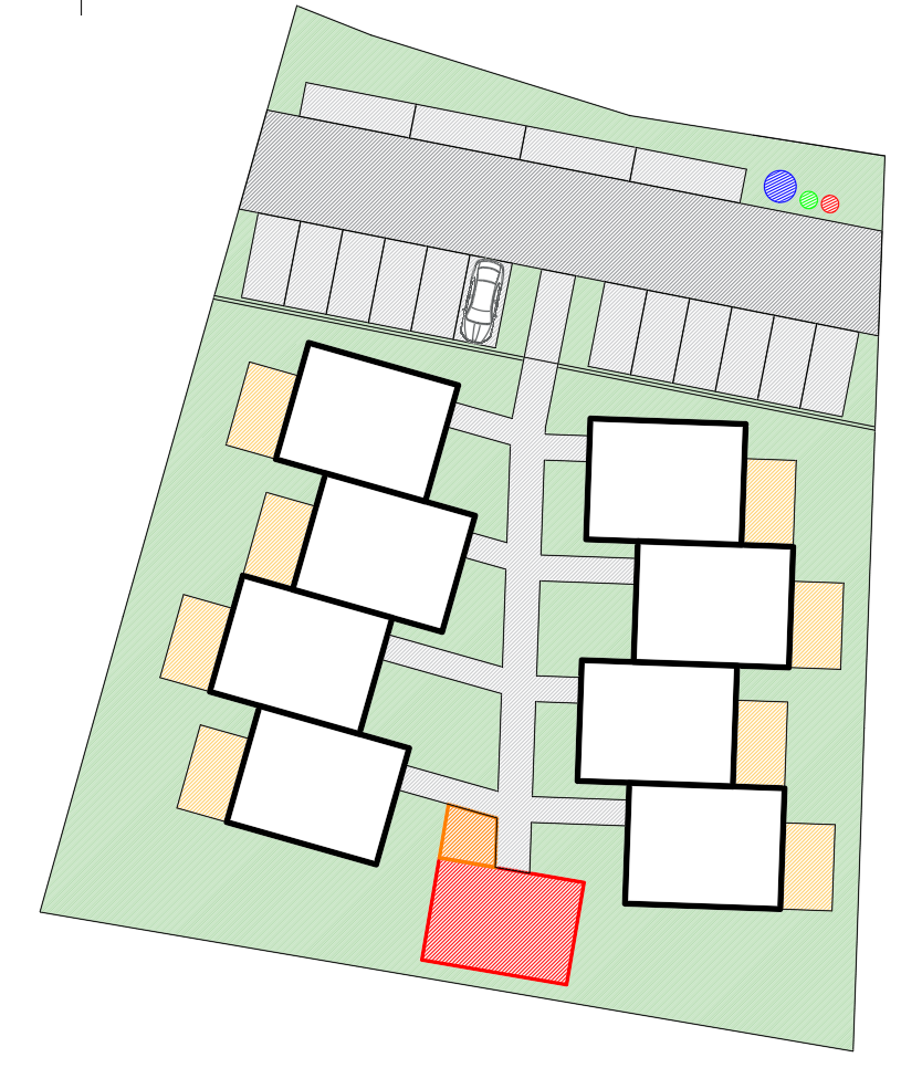
transform the provided 2d autocad site plan into a highly photorealistic aerial architectural visualization of a contemporary residential development critical strictly preserve the original site plan geometry maintain the exact positions footprints orientations proportions and number of buildings preserve all roads driveways plot boundaries and spatial relationships exactly as shown in the reference drawing do not redesign or reinterpret the masterplan convert the 2d building footprints into realistic contemporary single family houses with pitched roofs minimalist architectural forms light plaster facades natural timber accents and dark grey metal roofing create a realistic residential environment with asphalt access roads paved driveways pedestrian paths green lawns private gardens subtle landscaping scattered trees and natural vegetation surround the development with realistic lithuanian suburban landscape camera high angle oblique aerial drone view approximately 45 degrees downward capturing the entire development in one composition maintain accurate architectural proportions and realistic perspective visual style premium european architectural competition visualization photorealistic materials natural summer daylight soft shadows realistic vegetation subtle atmospheric depth professional architectural rendering 8k quality create a highly photorealistic aerial architectural visualization based strictly on the provided autocad site plan the provided drawing is the absolute primary reference and must be followed precisely this is a visualization task not a design task do not redesign reinterpret rearrange or modify any elements shown in the original drawing maintain the exact number location orientation footprint shape and proportions of all buildings strictly preserve the geometry of roads driveways pathways plot boundaries and all other elements shown in the drawing every building must correspond directly to its footprint in the provided plan do not invent relocate rotate resize or add buildings do not change the site layout under any circumstances use the drawing as a fixed geometric blueprint only enhance it by adding realistic architectural materials roof surfaces natural vegetation lawns paving textures lighting and environmental details without changing the underlying geometry generate a realistic contemporary lithuanian residential neighborhood with minimalist single family houses natural facade materials realistic landscaping and surrounding greenery camera professional aerial drone photography elevated bird s eye perspective approximately 45 degrees downward showing the entire site development style ultra photorealistic architectural visualization natural daylight realistic shadows detailed materials professional architectural competition rendering most important geometric accuracy and strict compliance with the provided autocad drawing take absolute priority over visual creativity create a highly photorealistic aerial architectural visualization based strictly on the provided autocad site plan the provided drawing is the absolute primary reference and must be followed precisely this is a visualization task not a design task do not redesign reinterpret rearrange or modify any elements shown in the original drawing maintain the exact number location orientation footprint shape and proportions of all buildings strictly preserve the geometry of roads driveways pathways plot boundaries and all other elements shown in the drawing important the upper part of the provided site plan is a parking area not a residential building area the elements shown at the top of the drawing represent parking spaces for vehicles visualize this area as a realistic outdoor parking lot with clearly defined parking bays appropriate paving and parked cars do not generate any houses buildings or roof structures in this area strictly preserve the parking layout and its position as shown in the reference drawing every building must correspond directly to its footprint in the provided plan do not invent relocate rotate resize or add buildings do not change the site layout under any circumstances use the drawing as a fixed geometric blueprint only enhance it by adding realistic architectural materials roof surfaces natural vegetation lawns paving textures lighting and environmental details without changing the underlying geometry generate a realistic contemporary lithuanian residential neighborhood with minimalist single family houses natural facade materials realistic landscaping and surrounding greenery camera professional aerial drone photography elevated bird s eye perspective approximately 45 degrees downward showing the entire site development style ultra photorealistic architectural visualization natural daylight realistic shadows detailed materials professional architectural competition rendering most important geometric accuracy and strict compliance with the provided autocad drawing take absolute priority over visual creativity create a highly photorealistic aerial architectural visualization based strictly on the provided autocad site plan the provided drawing is the absolute primary reference and must be followed precisely this is a visualization task not a design task do not redesign reinterpret rearrange or modify any elements shown in the original drawing maintain the exact number location orientation footprint shape and proportions of all buildings strictly preserve the geometry of roads driveways pathways plot boundaries and all other elements shown in the drawing important parking area the upper part of the provided drawing represents an outdoor parking area not residential buildings visualize it as a realistic parking lot with clearly marked parking spaces appropriate paving and a few parked cars do not generate houses or any other buildings in this area site boundaries and surroundings the visualization must focus exclusively on the area defined by the provided autocad drawing do not invent additional buildings roads neighborhoods or landscape features outside the drawing boundaries prefer a minimal neutral surrounding environment if no contextual information is provided if surrounding landscape is necessary it must resemble the natural environment of vilnius lithuania typical northern european vegetation deciduous trees such as birch maple and oak occasional pine trees natural grass and restrained landscaping absolutely no palm trees tropical plants mediterranean vegetation exotic landscaping or southern european scenery the environment must feel authentic to lithuania not a warm climate resort every building must correspond directly to its footprint in the provided plan do not invent relocate rotate resize or add buildings use the drawing as a fixed geometric blueprint only enhance it with realistic architectural materials roof surfaces vegetation paving textures and natural lighting without changing the underlying geometry camera professional aerial drone photography elevated bird s eye perspective approximately 45 degrees downward showing the entire site development style ultra photorealistic contemporary lithuanian residential development natural northern european summer daylight realistic shadows detailed materials restrained landscaping professional architectural competition rendering highest priority strict geometric accuracy and complete compliance with the provided autocad drawing create a highly photorealistic aerial architectural visualization based strictly on the provided autocad site plan the provided drawing is the absolute primary reference and must be followed precisely this is a visualization task not a design task do not redesign reinterpret rearrange or modify any elements shown in the original drawing building typology terraced row houses all residential buildings shown in the drawing are attached row houses terraced houses not detached single family houses the individual residential units are connected directly to one another forming continuous building blocks with shared party walls strictly preserve the number of units their connections building footprints orientations proportions and arrangement exactly as indicated in the autocad drawing do not introduce gaps between attached units or separate them into individual detached buildings parking area the upper part of the provided drawing represents an outdoor parking area not residential buildings visualize it as a realistic parking lot with clearly marked parking spaces appropriate paving and a few parked cars do not generate any buildings in this area site geometry strictly preserve all roads driveways pedestrian paths plot boundaries and spatial relationships every building must correspond directly to the exact footprint shown in the drawing do not relocate rotate resize add or remove any structures site boundaries and surroundings focus exclusively on the area defined by the provided drawing do not invent additional buildings roads or neighborhoods outside the site boundaries prefer a minimal neutral environment beyond the drawing if surrounding vegetation is necessary it must resemble vilnius lithuania with typical northern european deciduous trees birches maples oaks occasional pines natural grass and restrained landscaping absolutely no palm trees tropical plants mediterranean vegetation or exotic landscaping architecture contemporary lithuanian terraced housing development minimalist architectural forms light plaster facades subtle natural timber accents and dark grey pitched roofs maintain the exact building configurations and roof geometry indicated in the drawing wherever identifiable camera professional aerial drone photography elevated bird s eye perspective approximately 45 degrees downward capturing the entire residential development in one composition visual style ultra photorealistic architectural visualization natural northern european summer daylight realistic shadows detailed materials restrained landscaping professional architectural competition rendering highest priority absolute geometric accuracy and strict compliance with the provided autocad drawing no detached houses no gaps between attached units no additional buildings no altered footprints no modified roads no buildings in the upper parking area no palm trees no tropical vegetation no invented surroundings no modifications to the original masterplan